The Sinking Soils of Amstel, Gooi & Vecht

The first project after starting the MSc Geo-Information Science was to develop a StoryMap based on a environmental topic in your country. As we had The Netherlands, we chose the topic: “The Sinking Soils of Amstel, Gooi & Vecht”. In approximately a week we (Lena Sakalak, Juriaan Rijsdijk, Ilse Radix, Francesco Pasanisi, Liam Adam, and I) developed and researched the issue of soil subsidence in the region of the water board.
Together we de developed a cohesive story surrounding the issue with maps (e.g., land use, soil types) and pictograms. In the meanwhile, Francesco Pasanisi and I developed a script to analyze soil subsidence using the AHN data (Algemeen Hoogtebestand Nederland; national DEM of The Netherlands).

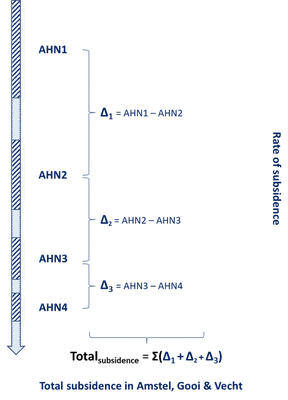
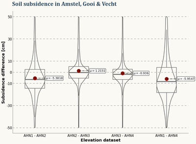
Substracting each dataset with the previous version allowed us to get a rate of subsidence, and the total subsidence throughout the area. This data was joined to building footprints to allow homeowners to get actual insight on the potential sinking of their house since 1997.

The final results, and the Esri StoryMap can be seen here.

Note that this was more of an experiment as more reliable methods are available through the usage of InSAR as can be seen by the Bodemdalingskaart 2.0 as developed by SkyGeo